Portal:Colombia
Colombia articles: History | Politics | Geography | Provinces | Economy | People | Culture | Café de Colombia | and much more...
The Colombia Portal
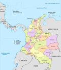
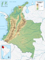
Colombia, officially the Republic of Colombia, is a country primarily located in South America with insular regions in North America. The Colombian mainland is bordered by the Caribbean Sea to the north, Venezuela to the east and northeast, Brazil to the southeast, Ecuador and Peru to the south and southwest, the Pacific Ocean to the west, and Panama to the northwest. Colombia is divided into 32 departments. The Capital District of Bogotá is also the country's largest city hosting the main financial and cultural hub. Other major urbes include Medellín, Cali, Barranquilla, Cartagena, Santa Marta, Cúcuta, Ibagué, Villavicencio and Bucaramanga. It covers an area of 1,141,748 square kilometers (440,831 sq mi) and has a population of around 52 million. Its rich cultural heritage—including language, religion, cuisine, and art—reflects its history as a colony, fusing cultural elements brought by immigration from Europe and the Middle East, with those brought by the African diaspora, as well as with those of the various Indigenous civilizations that predate colonization. Spanish is the official language, although Creole, English and 64 other languages are recognized regionally. Colombia has been home to many indigenous peoples and cultures since at least 12,000 BCE. The Spanish first landed in La Guajira in 1499, and by the mid-16th century, they had colonized much of present-day Colombia, and established the New Kingdom of Granada, with Santa Fé de Bogotá as its capital. Independence from the Spanish Empire was achieved in 1819, with what is now Colombia emerging as the United Provinces of New Granada. The new polity experimented with federalism as the Granadine Confederation (1858) and then the United States of Colombia (1863), before becoming a republic—the current Republic of Colombia—in 1886. With the backing of the United States and France, Panama seceded from Colombia in 1903, resulting in Colombia's present borders. Beginning in the 1960s, the country has suffered from an asymmetric low-intensity armed conflict and political violence, both of which escalated in the 1990s. Since 2005, there has been significant improvement in security, stability, and rule of law, as well as unprecedented economic growth and development. Colombia is recognized for its healthcare system, being the best healthcare in Latin America according to the World Health Organization and 22nd in the world. Its diversified economy is the third-largest in South America, with macroeconomic stability and favorable long-term growth prospects. Colombia is one of the world's seventeen megadiverse countries; it has the highest level of biodiversity per square mile in the world and the second-highest level overall. Its territory encompasses Amazon rainforest, highlands, grasslands and deserts. It is the only country in South America with coastlines (and islands) along both the Atlantic and Pacific oceans. Colombia is a key member of major global and regional organizations including the UN, the WTO, the OECD, the OAS, the Pacific Alliance and the Andean Community; it is also a NATO Global Partner and a major non-NATO ally of the United States. (Full article...) Selected article -The Spanish conquest of the Muisca took place from 1537 to 1540. The Muisca were the inhabitants of the central Andean highlands of Colombia before the arrival of the Spanish conquistadors. They were organised in a loose confederation of different rulers; the psihipqua of Muyquytá, with his headquarters in Funza, the hoa of Hunza, the iraca of the sacred City of the Sun Sugamuxi, the Tundama of Tundama, and several other independent caciques. The most important rulers at the time of the conquest were psihipqua Tisquesusa, hoa Eucaneme, iraca Sugamuxi and Tundama in the northernmost portion of their territories. The Muisca were organised in small communities of circular enclosures (ca in their language Muysccubbun; literally "language of the people"), with a central square where the bohío of the cacique was located. They were called "Salt People" because of their extraction of salt in various locations throughout their territories, mainly in Zipaquirá, Nemocón, and Tausa. For the main part self-sufficient in their well-organised economy, the Muisca traded with the European conquistadors valuable products as gold, tumbaga (a copper-silver-gold alloy), and emeralds with their neighbouring indigenous groups. In the Tenza Valley, to the east of the Altiplano Cundiboyacense where the majority of the Muisca lived, they extracted emeralds in Chivor and Somondoco. The economy of the Muisca was rooted in their agriculture with main products maize, yuca, potatoes, and various other cultivations elaborated on elevated fields (in their language called tá). Agriculture had started around 3000 BCE on the Altiplano, following the preceramic Herrera Period and a long epoch of hunter-gatherers since the late Pleistocene. The earliest archaeological evidence of inhabitation in Colombia, and one of the oldest in South America, has been found in El Abra, dating to around 12,500 years BP. The main part of the Muisca civilisation was concentrated on the Bogotá savanna, a flat high plain in the Eastern Ranges of the Andes, far away from the Caribbean coast. The savanna was an ancient lake, that existed until the latest Pleistocene and formed a highly fertile soil for their agriculture. The Muisca were a deeply religious civilisation with a polytheistic society and an advanced astronomical knowledge, which was represented in their complex lunisolar calendar. Men and women had specific and different tasks in their relatively egalitarian society; while the women took care of the sowing, preparation of food, the extraction of salt, and the elaboration of mantles and pottery, the men were assigned to harvesting, warfare, and hunting. The guecha warriors were tasked with the defence of the Muisca territories, mainly against their western neighbours; the Muzo ("Emerald People") and the bellicose Panche. To impress their enemies, the Muisca warriors wore mummies of important ancestors on their backs, while fighting. In their battles, the men used spears, poisoned arrows, and golden knives. (Full article...)Related portalsCategoriesSelected biography -The Cesar-Ranchería Basin (Spanish: Cuenca Cesar-Ranchería) is a sedimentary basin in northeastern Colombia. It is located in the southern part of the department of La Guajira and northeastern portion of Cesar. The basin is bound by the Oca Fault in the northeast and the Bucaramanga-Santa Marta Fault in the west. The mountain ranges Sierra Nevada de Santa Marta and the Serranía del Perijá enclose the narrow triangular intermontane basin, that covers an area of 11,668 square kilometres (4,505 sq mi). The Cesar and Ranchería Rivers flow through the basin, bearing their names. The basin is of importance for hosting the worldwide tenth biggest and largest coal mine of Latin America, Cerrejón. The coals are mined from the Paleocene Cerrejón Formation, that also has provided several important paleontological finds, among others Titanoboa cerrejonensis, with an estimated length of 14 metres (46 ft) and a weight of 1,135 kilograms (2,502 lb), the biggest snake discovered to date, the giant crocodylians Cerrejonisuchus improcerus, Anthracosuchus balrogus and Acherontisuchus guajiraensis, and the large turtles Carbonemys cofrinii, Puentemys mushaisaensis and Cerrejonemys wayuunaiki. Various genera of flora, as Aerofructus dillhoffi, Menispermites cerrejonensis, M. guajiraensis, Montrichardia aquatica, Petrocardium cerrejonense and P. wayuuorum, Stephania palaeosudamericana and Ulmoidicarpum tupperi among others, have been found in the Cerrejón Formation, the sediments of which are interpreted as representing the first Neotropic forest in the world. Mean annual temperature has been estimated to have been between 28.5 and 33 °C (83.3 and 91.4 °F) and yearly precipitation ranging from 2,260 to 4,640 millimetres (89 to 183 in) per year. (Full article...)Did you know (auto-generated)
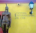
General imagesThe following are images from various Colombia-related articles on Wikipedia.
Selected pictureLargest cities
TopicsNew articlesThis list was generated from these rules. Questions and feedback are always welcome! The search is being run daily with the most recent ~14 days of results. Note: Some articles may not be relevant to this project.
Rules | Match log | Results page (for watching) | Last updated: 2024-05-16 20:00 (UTC) Note: The list display can now be customized by each user. See List display personalization for details.
WikiprojectsThings you can doIf you are interested in helping with this portal, please join WikiProject Colombia or one of its child projects: Article requests
History (High priority)
Society
Scouting
People (Medium priority)Physical geography
Media (Medium Priority)Government and political affairs (High priority)
Wikipedia's portalsDiscover Wikipedia using portals Sources | |||||||||||||||||||||||||||||||||||||||||||||||||||||||||||||||||||||||||||||||||||||||||||||||||||||||||||||||


![Image 2Tall ship ARC Gloria, insignia of Colombia. She is a training ship and official flagship of the Colombian Navy.[1]](http://upload.wikimedia.org/wikipedia/commons/thumb/e/eb/ARC_Gloria_by_Will_White.png/120px-ARC_Gloria_by_Will_White.png)


